According to the ATC - CRJ - PAT recordings being played all over the internet, ATC warned PAT about CRJ and to go behind it. PAT confirmed that they had them on visual and requested "visual separation." According to commentary by pilots and experts, requesting ****"visual separation"**** means they've got it, they don't need the ATC to control the situation any more. "Requesting visual separation" released the ATC to direct their attention and efforts elsewhere (other aircraft). ATC _DID_ alert PAT again and PAT confirmed visual again and repeated the request for "visual separation." One commenter did say that the ATC could have been more specific and said something like "Do you have a visual on CRJ ****AT 2 o'clock****?" (or wherever it was). If PAT had a visual on the trailing aircraft, they might have been looking at 9 o'clock. "Huh? What? We have a visual at 9 o'clock. That's not CRJ? Somebody look to the right. ... Oh crap! Plane at 2 o'clock! Dive! Dive!" Adding the "at 2 o'clock" detail MIGHT have prevented the collision.
.
There is still no explanation of why the PAT helo was at 300-400 ft and not at 200 ft or below. Maybe their altimeter was not working properly. The NTSB will try to figure that out and check maintenance logs and problem reports.
.
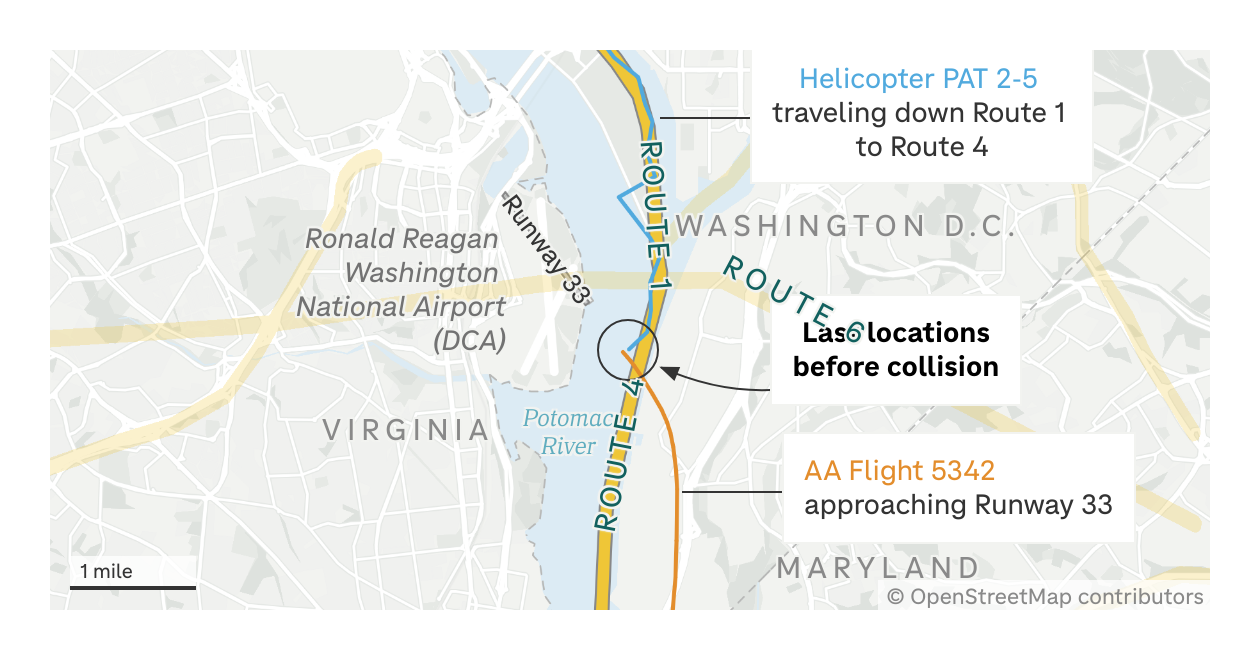
Also, RR might be amazed at these maps that show the helo routes near DCA and the data, below, about the number of helos flying around DCA (88,000 helo flights in just 3 years!) ... albeit without incident.
.
http://www.npr.org/2025/01/31/nx-s1-5282238/map-helicopter-traffic-dca-plane-crash
Map: A look at helicopter traffic patterns over D.C. - January 31, 2025
.
"FAA designated helicopter routes near Ronald Reagan Washington National Airport. There are six routes helicopters can take near DCA, including one that follows the Potomac and crosses in front of runway 33.
.
"Several helicopter routes pass by and even over DCA, including the one followed by the Black Hawk helicopter that crashed into the inbound American Airlines flight on Wednesday. The recommended maximum altitude for helicopters on this route is 200 feet. AA Flight 5342's last transmitted altitude was approximately 300 feet. ...
.
"Commercial planes also share the skies with helicopters. Over a three-year period ending in 2019, there were about 88,000 helicopter flights within 30 miles of Reagan National Airport, including about 33,000 military and 18,000 law enforcement flights, according to a Government Accountability Office report published in 2021. ... "
.
See the article for another map (only one image per post). See the map image posted below and maybe a Washingtonian can please help me with this: What is the Virginia nighttime skyline along the line of sight of the helo pilot just before the collision? I.e., extend the last segment of the blue flight path southwest towards the "A" in "VIRGINIA" and northeast towards the "W" in "WASHINGTON." Are there any photographs from any time (not even the night of the collision) of what the VA skyline normally looks like from the northeast side of the river? Are there bright lights? Big lights? Flashing lights? Construction lights? Etc..
Posted By: RespectfulRobert
Re: There are already saying the training flights will be moved.
Why they would be anywhere near that crowded air space to begin with is crazy. No helo should ever be crossing the final approach line for a landing plane. As to all the reasons that this may have happened you have done a nice job of covering the possibilities, as per usual. But moving the helos out of that immediate area seems like priority number one and then let the investigation play out.
.
Let's hope Trump fires all the midget pilots and every lesbian air traffic controller bc as Willy so rightfully pointed out, they are clearly the main problem. smh
EDIT: The posted image is slightly distorted from the image in the original NPR link. The "line of sight" in the distorted image would be more like A-to-H in "virginiA to blue---line to wasHington". And the distortion might vary more on other computers and browsers.
-- Modified on 1/31/2025 7:32:06 PM